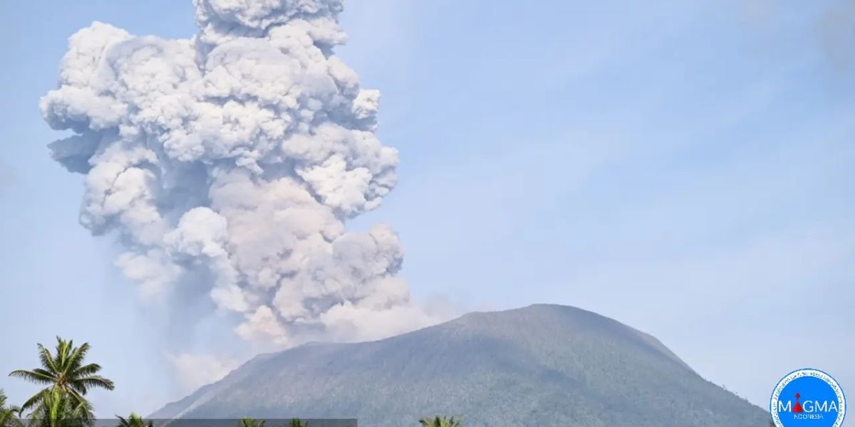
Kapanlagi.com - The majestic Mount Ibu in West Halmahera, North Maluku, has once again shown its power with a massive eruption on the night of Wednesday, January 15, 2025. In this thrilling moment, the sharply increased volcanic activity prompted the Geological Agency to announce an upgrade in the mountain's status from Alert (Level III) to Warnings (Level IV).
As a proactive measure, more than 3,000 residents from six villages at the foot of the mountain have been evacuated to safe locations. This eruption has become one of the most concerning in recent years, with an ash column rising up to 4,000 meters and glowing lava posing a threat. The local government has also moved quickly to address this situation.
A joint team from the Regional Disaster Management Agency (BPBD), the military (TNI), the police (Polri), and various related agencies has been working tirelessly to evacuate residents. According to official data from BNPB, the affected villages are within a 6-kilometer radius of the active crater of Mount Ibu. The evacuees have been relocated to two main evacuation points to ensure their safety from volcanic material hazards such as ash, glowing rocks, and lava flows.
1. Mount Ibu Raises Status to Level IV Alert
On Wednesday, January 15, 2025, Mount Ibu officially raised its status to Level IV Alert, a step taken after the Geological Agency team detected a significant increase in volcanic activity between January 1 and 14.
The Head of the Volcanology Center announced that the danger radius has now expanded to 6 kilometers from the active crater, following alarming reports from the Mount Ibu Observation Post in Gam Ici Village, West Halmahera, which recorded an average of 70 eruptions per day.
During this period, the height of the eruption column showed remarkable fluctuations, peaking at up to four kilometers above the crater.
Other shocking data includes 748 explosive earthquakes, 70 collapse earthquakes, 1,643 puffing earthquakes, as well as thousands of shallow and deep volcanic earthquakes, indicating that Mount Ibu is in a highly active phase and requires caution.
2. Evacuation of Residents from Six Villages at Night
On the night of Wednesday, January 15, 2025, a massive evacuation began in the village of Sangaji Nyeku, which became the starting point for the rescue of residents. A joint team promptly prioritized vulnerable groups, such as the elderly, pregnant women, and children, to ensure their safety.
In a simultaneous effort, five other villages, including Tuguis and Todoku, were also evacuated to avoid the threat of danger. The Regional Disaster Management Agency (BPBD) actively participated by preparing two main evacuation locations in the villages of Akesibu and Tongute Sungi, chosen for being far from high-risk zones and capable of accommodating thousands of refugees.
3. Impact of Eruption on the Environment
Volcanic eruptions not only pose a direct threat to human life but also disrupt the balance of the surrounding ecosystem. The thick layer of volcanic ash covers agricultural fields and contaminates clean water sources, raising concerns among residents.
In an effort to protect the community, local authorities urged everyone to wear masks to avoid exposure to harmful ash.
On the other hand, heavy rains in the area increase the risk of lahar flows in the rivers flowing from Mount Ibu, making residents outside the evacuation zone remain vigilant against the potential secondary disasters that could threaten their safety.
4. Inter-Agency Coordination in Emergency Response
The government of West Halmahera has officially declared a state of emergency for 14 days, mobilizing various agencies such as the military, police, and search and rescue teams to actively participate in the evacuation and distribution of logistics.
Amid these rescue efforts, food and medicine are beginning to flow to evacuation points, while the central government is also providing additional support to expedite the handling of the situation.
"Field coordination in West Halmahera has been well established, now it's just a matter of mobilizing it," said the Head of the Data, Information and Disaster Communication Center of BNPB, Abdul Muhari, in his statement in Jakarta on Thursday (16/1/2025), as reported by Liputan6.com.
5. Mitigation Efforts and Community Awareness
In an effort to protect the communities around Mount Ibu, the government is determined to strengthen disaster mitigation programs with a focus on socializing evacuation routes and emergency response procedures that will be the top priority.
Another strategic step is the establishment of danger zones, aimed at preventing human activities in areas prone to eruptions. For the sake of public safety, tourists are also urged to stay away from the Mount Ibu area until the situation stabilizes.
6. What causes Mount Ibu to erupt frequently?
Mount Ibu is a stratovolcano that has active volcanic activity due to the subduction process of tectonic plates beneath the Maluku Sea. Pressure from magma within the earth often triggers eruptions.
7. What should be done during volcanic ash rain?
Use masks and goggles to protect your respiratory system and eyes. Avoid outdoor activities unless necessary. Ensure that clean water sources are not contaminated with ash.
8. What is the danger radius of Mount Ibu currently?
The danger radius of Mount Ibu is 5 kilometers from the active crater, with a sectoral extension up to 6 kilometers towards the crater opening.
(kpl/rmt)
Disclaimer: This translation from Bahasa Indonesia to English has been generated by Artificial Intelligence.


